Part 2,
Page 1 of 5
Trek Across Moore
Prev
Page


Next
Page
|
Part 2, |
Trek Across Moore |
Prev |
|
|
Next |
|
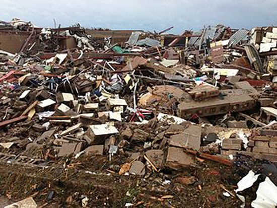
Trek Across Moore - Part 2 (May 20, 2013) (Rev F: 5/4/2020)
After finding out about my sister, Deanna, my next thought was to check the welfare of her son (my nephew), Mark Stephens, who, as you will recall, was injured alongside his mother. Also, I needed to check on my niece, Shelley Irvin (Deanna's daughter, Mark's sister), and her family. The Irvin home was only about six blocks away. I felt like if I could go there first and find them, then we could pool our resources to find Mark. [At this time, I didn't know that when the tornado hit, a third person, whose identity I'll temporarily leave unknown, had been there with Deanna and Mark as the tornado first struck the Ridgeline/Plaza Towers neighborhood.]
|
The Irvins' home lay on a straight line roughly halfway between my sister's house/Plaza Tower Elementary and the Moore Medical Center. I think that at this point, in order to be clear about several aspects of the story, especially the beginning of tomorrow's Part 3, I need to describe the geography of this section of Moore. I'm not sure I can do this without a map, but I'm going to try. If you're interested, feel free to grab a map and try to follow along. I hope I don't make this description too convoluted, so that it doesn't make sense even for those who live there. If I do, I think I can reasonably claim that it's not entirely my fault. As we go along, I think you can see why. (Oh well, blame me anyway, but I think you'll at least see that I didn't have anything to do with the geographic oddities of the path that the killer tornado chose to take.) Draw a line starting from the middle of Ridgeway Street or, if you prefer, Plaza Towers Elementary School, northeast to just east of Telephone Road about halfway north and south between the Moore Medical Center and the Warren Theatre. If you got it right, it should just cross the southeast corner of a big area Moore calls "The Tom Strouhal Little River Park". I don't know what all is included in this park though it seems to contain the usual park stuff ─ walking trails and so on ─ as well as maybe a cemetery and maybe a golf course. It definitely contains "Little River" which is really a creek; this creek comes out of the southeast corner of the park and continues on south and east till it leaves Moore. But as it leaves the park, and for the next quarter of a mile or so, it is flanked on both sides (yes, both sides) by a street called South Janeway Avenue - neither East Janeway nor West Janeway, nor any |
